Hong Kong metro map
You can find on this page the Hong Kong metro map to print and to download in PDF. The Hong Kong metro map presents the network, zones, stations and different lines of the metro of Hong Kong in China.
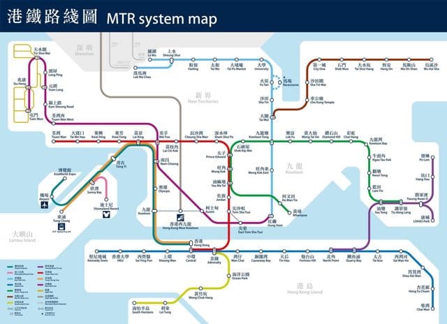
Metro map Hong Kong
The Hong Kong metro map shows all the stations and lines of the Hong Kong metro. This metro map of Hong Kong will allow you to easily plan your routes in the metro of Hong Kong in China. The Hong Kong metro map is downloadable in PDF, printable and free.
MTR runs the Hong Kong MTR metro system. Hong Kong MTR system boasts four kinds of metro lines which are serving in different areas as its shown in Metro map Hong Kong. More metro lines are in the plan, including Shatin - Central Line, Tuen Mun South Extension, Tung Chung Wesy Extension and Kowloon East Extension.
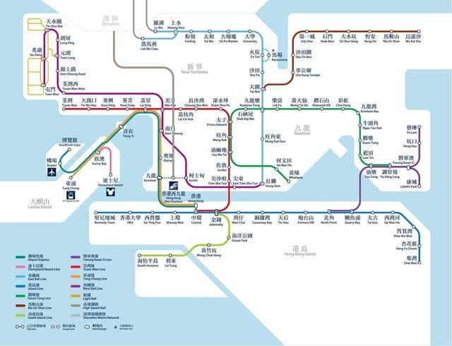
Hong Kong subway map
The Hong Kong subway map shows all the stations and lines of the Hong Kong subway. This subway map of Hong Kong will allow you to easily plan your routes in the subway of Hong Kong en China. The Hong Kong subway map is downloadable in PDF, printable and free.
Hong Kong subway system is generally considered to be the best in the world. Passengers can enjoy all the benefits of high technology, safety, cleanliness. Tourists can use the Hong Kong subway system to enjoy all the excellent highlights and best shopping places in this unique city (see Hong Kong subway map).